Sunday, January 14, 2024

Kinishba -- An Ancestral Pueblo Site

About an hour south of Show Low and five miles west of Fort Apache Historic Park in northern Arizona, an unpaved dirt road leads to Kinishba Ruins.  It’s a small site that once was home to Ancestral Pueblo people.

Photograph by author of entrance sign to Kinishba Ruins; sign looks like a fencepost; partial ruins are visible in the back and mountains are in the background
Entrance to Kinishba Ruins

The entrance fee to Fort Apache includes admittance to Kinishba.  At the Nohwiké Bágowa Museum, you can buy a small guidebook about the site.  I highly recommend purchasing it because there is no description at Kinishba of what you’re looking at.  But there are numbered posts that correspond to explanations in the guidebook about the buildings and spaces at the Kinishba; without the guidebook, I wouldn’t have known what I was looking at.

Photograph by author of one of the buildings at Kinishba; constructed of dry stone masonry, 2 walls on either side are only a few feet high but the wall perpendicular to them is room height and is supported by 3 logs propped against it and it has a window in the wall as well
One of the buildings at Kinishba

Occupied from sometime in the 9th century to a time period in the 15th century, the ruins consist of several buildings of dry stone construction.  Some buildings still have walls but others just show foundations that are a few feet high.  There are also a couple of plazas – small, squarish sections of land but it wasn’t obvious what those spaces were until I read about them in the guidebook.
 
At its height in the 14th century, as many as 800 people might have inhabited Kinishba.  The ruins are situated on a windswept plain, high above a river that ran along the edge of the settlement.  Kinishba was an agricultural village and evidence of pottery, jewelry, and artifacts have been found there.

Photograph by author of view looking west, with a river down below and mountains on the other side
View to the west of the river down below and mountains on the other side

In the 1930s, an archaeologist named Byron Cummings supervised the excavation of Kinishba by his students from the University of Arizona and members of the White Mountain Apache Tribe.  Cummings also constructed some buildings near the ruins; one served as a museum but it closed in 1952.  These buildings are now in a state of disrepair.

Photography by author of some of the dry stone buildings that Dean Byron Cummings built in the 1930s
Buildings built by UofA Dean Cummings to simulate the actual Kinishba ruins

When I visited last November, for most of the time I was the only person at Kinishba.  Two other people arrived at one point but they didn’t stay long, perhaps because they didn’t have the guidebook to tell them about the place.

Photograph by author of the interior of a buikdling at Kinishba, with the sun shining in the upper left of the image
View of interior of one of the buildings at Kinishba

I tried to imagine living there a thousand years ago but had a hard time visualizing what it must have been like when Kinishba was a vibrant community filled with people.  However, it is well worth the time to seek it out and I very much enjoyed the hour I spent at Kinishba.

Sunday, January 7, 2024

Fort Apache -- The Army Fort

Located on the White Mountain Apache Tribe’s land, Fort Apache was a U.S. Army fort in the 19th century and is now a National Historic Landmark.  I spent a day there last November, learning about Apache history, about the fort and its work, and what happened after the Army left.  The site looks nothing like the fort in the 1948 movie called Fort Apache, which I wrote about in another post.

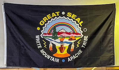
Photograph by the author of a black banner showing the Great Seal of the White Mountain Apache Tribe
Banner in the Arrowhead Cafe
 
Fort Apache is about five miles south of Whiteriver, just off Highway 73, in Navajo County, Arizona.  After paying the entrance fee which, at the time of my visit, was $10.00, you’ll get a map of the site which you can use to orient yourself.  However, I recommend buying the Fort Apache Walking Tour Guide because that contains a lot of background information.

Photograph by the author of the sign at the entrance to Fort Apache, made of wood to look like a fence with text in white and yellow paint, with trees behind it
Sign at entrance to Fort Apache Historic Park

To the left of the entrance, in the same building, is the Nohwiké Bágowa Museum.  Translated as House of Our Footprints, it provides an excellent introduction to Apache history and culture. You’ll definitely want to spend some time here to get an idea of how the Ndee people, the White Mountain Apache word for themselves, lived before, during, and after the Army occupied the place.
 
A well-stocked gift shop is also in the museum.  I had read online that everything sent from the post office here was stamped with a Fort Apache postmark, which I thought would be fun to have as a souvenir.  Another gift shop, with different items, is located in another building.

Photograph by the author of the front entrance to the U.S. Post Office on Fort Apache; the building is white with green pillars and roof accents
U.S. Post Office at Fort Apache

Fort Apache was originally called Camp Ord and was founded in 1870.  General George Crook enlisted the cooperation of local Apaches as scouts who helped the Army in their wars against other Indigenous people.  One of the buildings on the site has an exhibit with detailed information about why the White Mountain Apache people aided Crook in the Apache Wars in the second half of the 19th century.  There were economic, political, and other reasons but the exhibit also makes clear that the presence of the Army also completely changed the Apache people’s traditional way of life.  One very interesting fact is that 12 Apache scouts received the Congressional Medal of Honor in 1872.

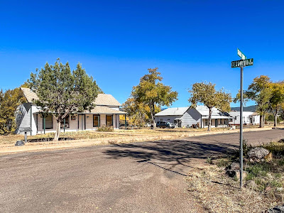
Photograph by the author of the intersection of General Crook Street and Geronimo Street, with 2 white buildings with green accents across the road
View of one area of Fort Apache

In 1922, the Army vacated Fort Apache.  The next year, an Indian boarding school was established on the fort’s grounds.  Named the Theodore Roosevelt School, today it’s a middle school for local children.

Photograph by the author of a panoramic view of Fort Apache; it is looking across a field to buildings on General Crook Street, with mountains in the backround
Another view of Fort Apache

Although Fort Apache isn’t large and following the walking tour won’t take long, if you stop to read all the information plaques, enter the buildings that are open to the public, eat in the Arrowhead café, browse the gift shops, take photos, and just soak up the atmosphere, you can easily spend several hours there, as I did.  Anyone who is interested in the Old West, Arizona history, Indigenous culture and history, and Army life will enjoy visiting Fort Apache Historic Park.